Projects - Bridgewater
Archaeological Phase I Survey, Phase II Testing and Phase III Data Recovery
US Custom and Border Protection Land Port of Entry Modernization Project
Bridgewater, Aroostook County, Maine
Client: Parsons, Geo-Marine, Inc. for U.S. Customs and Border Protection
Date completed: May 2009 – currently active
The U.S. CBP proposes to develop and expand a number of its Land Port of Entry facilities as part of a general, nationwide modernization project. The NE ARC has completed cultural resource management activities related to five such facilities within the State of Maine during 2009 and 2010, including architectural survey, Phase IA and IB surveys, Phase II testing and Phase III data recovery and mitigation.
The Bridgewater LPOE is situated adjacent to a small river confluence and is highly sensitive for both Native American and historic Euroamerican cultural resources. Initial Phase I survey and historic background research identified both a Native American and an historic site within the project Area of Potential Effect (APE), each with multiple loci. Although Phase II testing suggested that the Native American site was not significant with regard to the National Register of Historic Places, testing and background research for the historic site yielded artifacts and data suggesting that the ‘site’ in fact represented a small yet historically important 19th-century border hamlet focused on the construction and activities of a mill built on Prestile Stream, a tributary of the larger Saint John River which separates the U.S. and Canada.
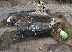
The NE ARC conducted archaeological Phase III data recovery excavations at the newly defined Boundary Line Mill Hamlet Historic District (ME 055-001) in order to aid CBP in avoidance and mitigation of this significant resource. Full mitigation involved the placement of buffer zones to avoid certain loci representing historic structures; data recovery of any unavoidable site loci and public education activities.
The Phase III archaeological work included the excavation of a total of 75 square meters throughout four separate site loci, representing two dwellings, a commercial lot and a blacksmiths shop. One feature consists of a collapsed domestic dwelling later used as a large domestic community refuse pit containing a rich suite of artifacts and ecofacts dating to the mid-19th century. Nearly 40,000 Historic artifacts were recovered which provides a unique glimpse of life in this small 19th century border hamlet.
Report: Scharoun, Stephen R., Jessica M. Stuart, Rosemary A. Cyr, Robert N. Bartone and Ellen R. Cowie (In Preparation)
2010 Archaeological Phase II Testing and Phase III Data Recovery and Mitigation of the Boundary Line Mill Hamlet Historic District, ME 055-001, within the Bridgewater Land Port of Entry Modernization Project Area for U.S. Customs and Border Protection, Aroostook County, Maine. Report submitted to Geomarine.
Projects
Contact Us
P: 207.860.4032
382 Fairbanks Rd
Farmington, Me 04938
Fax: 207.860.4031
nearc@nearchaeology.com